
Online platform Historical Maps of Southeast Asia launched
On August 30, the online platform Historical Maps of Southeast Asia was launched. The platform provides access to over 1,400 digitised maps of Southeast Asia from the collections of the National Library Board Singapore (307 maps), Beinecke Rare Book and Manuscript Library - Yale University (150 maps), Bodleian Libraries - University of Oxford (387 maps ) and Leiden University Libraries (UBL) (593 maps). The platform is limited to maps made before 1900. The new platform increases the availability of historical maps of Southeast Asia for researchers and the public. The project was led by Yale-NUS College in Singapore and funded through a Thematic Grant from Singapore's Ministry of Education Social Science Research (SSR).
Functionality
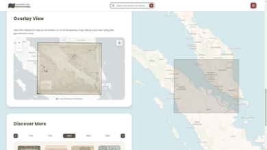
The platform provides users with extensive options to view and research the 1,437 digitised maps. Maps can be easily selected by period and collection. The historical maps can be viewed as a projection on a contemporary map of the same area. The way the maps are displayed can be easily adjusted using the geo-reference tool. Users can also search and filter by language, country and region, land use and buildings in the area, such as forts, villages, towns, palaces, trade and industry in the form of factories, markets, shopping areas and agriculture including crops, mining, plantations, fishing, etc. In addition, the maps can be consulted for cultural and political regions, environmental and landscape features such as mountains, volcanoes, reefs, jungles, wildlife, climate and rainfall. The maps are also searchable for technical aspects such as scale, latitude and longitude, compass roses and annotations. Furthermore, the maps have been made searchable by map maker, publisher and place of publication.
Various aspects of maps can be consulted via special 'MapJourneys', including cartouches, illustrations, coats of arms and insert cards. In addition, sub-regional maps can be viewed and attention is paid to travel routes and networks, including postal routes, train, tram and telegraph connections and shipping routes.
Cartographic collections UBL
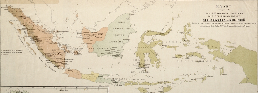
The UBL made 593 digitised maps available for the online platform Historical Maps of Southeast Asia. These maps were selected from the cartographic collections of the Royal Tropical Institute (KIT) and the Royal Institute of Linguistics, Land and Ethnology (KITLV), which have been managed by the UBL since 2013 and 2014. Both collections mainly focus on maps of the former Dutch colonies: Indonesia, Suriname and the Antilles. In addition, some maps from the UBL Bodel Nijenhuis collection were made available. This collection forms the foundation for the UBL cartographic collection and was built by Johannes Tiberius Bodel Nijenhuis. Upon his death in 1872, Bodel Nijenhuis bequeathed his vast and varied collection of maps and atlases to the UBL, including hundreds of unique, hand-drawn maps. Over the course of a century and a half, the collection received numerous additions through donations and purchases. At the end of 2021, the donation of the extensive private collection of John Steegh and Harrie Teunissen was added. With a total of approximately 120,000 historical maps and atlases, the UBL manages one of the largest cartographic collections in the Netherlands with an international focus.
